
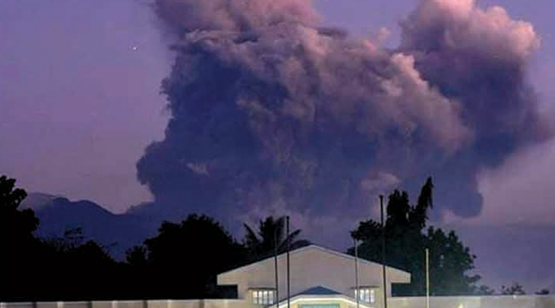
The wrath of Mt. Kanlaon in nearby Negros region spares Bohol and Cebu while the volcanic eruptions remained within below the “major†level.
Philippine Institute of Volcanology and Seismology (PHIVOLCS) Director Renato Solidum Jr. described that the eruptions of Mt. Kanlaon in Negros island are only intermittent and not a major eruption as he allayed fears that the eruption might affect either Cebu or Bohol at the current situation.
Solidum was in Bohol on Monday for a press conference on the Phivolcs-DOST Info-Sentro for the training of teachers on the operation of broadband seismic stations in at least three areas in the province—Talibon, Garcia-Hernandez, and Tagbilaran City.
The eruption will only affect Bohol or Cebu if it becomes stronger and blows ashes high and the wind carries it toward the neighboring provinces.
“If the eruption becomes stronger and major, and if produces a very tall eruption, and the wind would go towards your direction do’n lang mangyayari. Alam mo ang hangin ay habagat or amihan. Hindi kayo masyadong maabot,†according to Solidum.
He explained that the eruption is propelled by boiling of ground water wherein there is pressure on the steam that is produced during the boiling and usually produces ash.
When the wind heads to Cebu and Bohol, just then the ashes will reach these areas, but only when the eruption becomes strong and major.
“So ang hazard ay health hazard and also hazard sa aviation sector—‘yong eroplano. Minsan kung mag-landing at may abo sa kalsada, madulas ang kalsada. So far, with the current activity of Kanlaon, it’s not a problem for either Cebu or Bohol kasi maliliit pa lang ang eruptions,†according to Solidum.
EARTHQUAKE PREPARATIONS
On the other hand, Solidum announced during a press conference on Monday that Phivolcs aims to expand the Philippine Seismic Network by establishing additional earthquake monitoring stations located strategically all over the country.
Phivolcs-DOST has been installing broadband seismic stations since March 28 and already installed the 85th station in Tagbilaran City.
Three more broadband seismic stations will be installed in Cebu within this week —one in Medellin, one in San Francisco in Camotes Island, and one in Dalaguete.
The broadband seismic stations will significantly benefit the province through increased detectability of events and more accurate and timely determination of earthquake parameters of events generated by active earthquake sources in Bohol, according to Solidum.
New broadband seismic stations had been installed in Talibon, Garcia-Hernandez, and Lazi, Siquijor after 2013, while those in Lapu-lapu in Cebu, Maasin in Leyte, and Tagbilaran in Bohol, Hibok Hibok, and Sibulan in Negros Oriental were installed before 2013. Â Â Â Â Â Â Â Â Â Â The one in Lazi, Siquijor was installed on February 24.
Solidum said these instruments should be taken care of because “it is not easy to replaceâ€.
The housing costs around P1 million each, while the instrument costs P2.5-P3 million.
The Censor can detect earthquakes from around the world.
Phivolcs will place these instruments in strategic areas to form a triangle—Maasin, Leyte in the east, Surigao del Norte in the south and Cebu in the north.
The Tagbilaran station is manned by Nolan Evangelista—to locate earthquake sa faults.
Solidum said these parameters are important inputs for detailed delineation of earthquake hazards that could possibly affect the province which will then be used for disaster prevention, mitigation, preparedness, and response plans of the province. This will help teams to respond properly when an earthquake occurs.
In line with this, Phivolcs-DOST conducts a three-day trainers’ training from among the teachers on “communicating earthquake, tsunami and volcanic hazards†in the city starting yesterday (April 5) until April 7.
The three-day training aims to prime selected high school teachers in seven schools under the Tagbilaran City Division on basic information about the science of volcano, earthquake, tsunami and their hazards, and how to communicate these information to prepare their students.
On April 8, the Phivolcs team will be in Garcia Hernandez in the morning and Talibon in the afternoon. On April 11, they will be in Lazi, Siquijor.
The ongoing training for communicating earthquake, tsunami, and volcanic hazards for at Arabelle Suites in Tagbilaran City
is participated in by high school teachers from Cogon High School evening class, Dr. Cecilio Putong National High School, Manga National High School, Mansasa National High School, Tagbilaran City Science High School, San Isidro National High School, and Tagbilaran City SPED High School.
Through the information campaign, Phivolcs intends “to capacitate teachers to help schoolchildren learn how to prepare, respond, and protect oneself during earthquake and tsunami since children are vulnerable to the dangers brought by these occurencesâ€.
Solidum also explained that the magnitude 7.2 earthquake on October 15, 2013 in Bohol “was generated by the reverse fault movement of North Bohol Fault†and had caused a score of damage in different municipalities.
He said Phivolcs has also been conducting multi-hazard mapping and re-assessment and validation of previous hazard maps in Bohol.
“Updated hazard maps for ground shaking, ground rupture, liquefaction, earthquake-induced landslide, and tsunami are now available,†Solidum said.
After the earthquake in 2013, the Phivolcs Quick Response Team conducted the following activities: coordination with the Provincial Disaster Risk Reduction and Management Office (PDRRMO), MDRRMOs and barangays, installed additional five temporary seismic stations, information-education campaigns in affected barangays and municipalities, intensity surveys, impacts documentation; documentation on liquefaction, ground rupture, landslide; and surface rupture mapping.
Solidum also said Phivolcs installed a temporary network of seismographs to image the fault in Pilar, Talibon, Tagbilaran, Sagbayan, and Calape; and conducted surface rupture mapping of the North Bohol Fault.
Phivolcs traced surface rupture in barangay Anonang, Inabanga, made 12 Ground Control Points (GCP) for Digital Elevation Model (DEM), and conducted information disseminations in Inabanga (municipal-wide), Clarin (municipal-wide), Tubigon, Panganan Island, Calape (all barangays), Calape (municipal-wide), Buenavista (two sites), Pilar (two sites), Loon (three sites), Maribojoc (three barangays), Danao (one site), Sagbayan (seven sites), Catigbian (one site), San Isidro (four sites), Antequera (municipal- wide), other local government units and the teachers.
Others (LGUs, teachers, etc.
Recently, Phivolcs conducted earthquake hazard mapping, re-assessment and validation of previous hazard maps, installed earthquake monitoring stations around Bohol, conducted information campaign for earthquakes and tsunami for earthquake monitoring station hosted by LGUs, established Bohol and vicinity Earthquake Monitoring Network; and initiated the ongoing Teachers’ Training on Communicating Earthquake, Tsunami, and Volcanic Hazards.