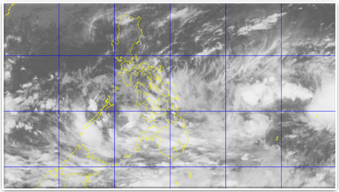
The Philippine Atmospheric, Geophysical and Astronomical Services Administration (PAGASA) attributed the recent sudden downpours in Bohol to the Low Pressure Area (LPA) near Surigao Del Sur in Mindanao.
According to PAGASA the LPA embedded in the Intertropical Convergence Zone (ITCZ) was already less than 500 kilometers east of Hinatuan in Surigao Del Sur.
“The LPA and the ITCZ will bring cloudy skies with light to moderate rains and isolated thunderstorms over Visayas, Mindanao, CALABARZON, MIMAROPA and Bicol Region,†the PAGASA advisory stated.
However, more rains are expected in Metro Manila and the rest of Luzon.
Bohol, so far, is spared form the gale warning as the strong to gale force winds associated with the northeast monsoon are only expected to affect Luzon areas such as the seaboards of Northern Luzon covering Batanes, Calayan, Babuyan, Cagayan, Ilocos Norte, Isabela, Ilocos Sur, La Union and Pangasinan.
The seas off Panglao have been less rough though not smooth as winds still blew over the coastline.
Panglao hosts the island-hopping adventures for tourists who are here for the holidays.
What have been experienced in the past days here were isolated thunderstorms and up to moderate rains, so far.
Still, fishermen had been advised to avoid sailing far as the winds from Mindanao brought strong current.
According to fish vendors at the public markets and fish terminal in Tagbilaran, they rely partly on the supply from Cebu and Mindanao at this time.
On the other hand, the municipal disaster risk reduction and management councils and the Philippine Coast Guard stay on alert, considering the number of bodies of water within Bohol which water levels might rise once it rains hard.
The Municipal Local Government Operations Officers (MLGOOs) have been coordinating with the MDRRMCs for the constant update of the response standards, and equipping the quick response teams.
The MDRRMCs closely watch the communities near riverbanks and the coastlines which are more vulnerable to disasters during the wet season.
