Weather systems packing the southern part of the country may bring a stormy Christmas this weekend.
The weather system heading the south of the Philippines may yet bring remote possibility of rain to Bohol.
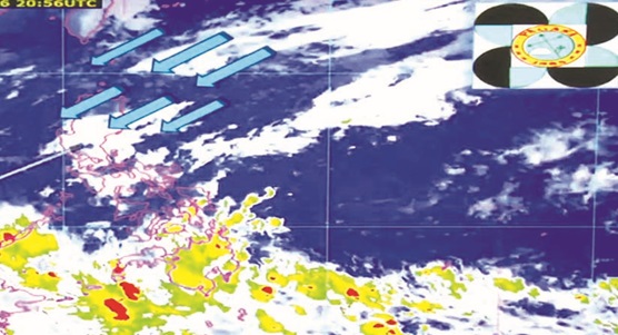
Satellite images show a weak low pressure area heading south of Philippines.
Bohol continues to have “fair to partly cloudy skies†with slim chance of rain though as a tropical cyclone “continues moving to west north-west direction toward Surigao del Sur area.
The tropical cyclone is expected to develop into a tropical depression today and may enter the Philippine Area of Responsibility tomorrow (December 22).
Based on the current direction of the wind, it is expected to make a land fall by December 24 through Central Visayas.
As of yesterday, Philippine Atmospheric Geophysical and Astronomical Services Administration (PAGASA) already issued gale warning in the northern and eastern seaboards of Northern Luzon, covering the Batanes, Calayan, Babuyan, Ilocos Norte, Cagayan and Isabela areas.
The gale warning in the eastern seaboard of Central and Southern Luzon covers Aurora, Camarines provinces, Catanduanes, Eastern coast of Albay, Eastern coast of Sorsogon and Easterne coast of Quezon including Polilio Island.
Sea condition in these areas has been moderate to rough with wave height reaching 2.1 to four meters.
PAGASA’s final gale warning yesterday alerted fishing boats and other small seacrafts venturing in these areas against moderate to rough seas.
Bohol and other tourist destinations in Visayas might absorb the spillover of tourists in these affected areas, prompting preparations for the influx of tourists coupled with pre-emptive measures upon the looming typhoon by Christmas eve.
Shipping and airline companies have been monitoring the weather systems since yesterday since it’s the peak season for travel.
Hotels and resorts in Bohol have also maintained constant coordination with thePAGASA, aside from staying in contact with local disaster risk reduction and management councils of the local government units in their respective areas.
The city disaster risk reduction and management council also extends monitoring through the forecasts from Weather Philippines monitoring.
Weather forecast tracked the weak LPA at the tail of the Near-Equatorial Trough towards Surigao del Sur area as of yesterday.
The “Near-Equatorial Trough and an embedded weak LPA near 575 kilometers southwest of Chuuk State brings isolated to scattered rain showrs and thunderstorms across the southernmost portions of Western and Central Micronesia.
Weatherphilippines tracks the Intertropical convergence zone behind the trough at Kosrea, “the second largest and eastern most island in the Federated States of Micronesia†yesterday.
The surface trough from the west also is expected to bring “isolated scattered rain showers and thunderstorms across Eastern coast of Vietnam, the Kalayaan island group, including the southernmost tip of Palawan and the Sulu Sea regionâ€.
On the north, the northeast monsoon brings cloudy skies and occasionally light rains from the tip of Luzon down to areas north of Dagupan area.
The weather philippines forecast says the “northeast monsoon continues to bring partly to mostly cloudy skies with cooler conditions with some occasionally light rains across the northern and eastern coasts of Luzonâ€.
In these areas of the country, “moderate breeze of winds (25-40 kilometers per hour) prevail along its seabords where the seas around remain treacherous for small to medium-sized seacrafts to navigate onâ€.
In the south of the country, the weather systems have started bringing thunderstorms with moderate to heavy and sometimes extreme rainfall.
Severe thunderstorms usually cause flashfloods or landslides.
Weather experts explained that a tropical depression forms after “a group of thunderstorms come together under the right atmospheric conditions for a long enough timeâ€.
In this event, “winds near the center are constantly between 20 and 34 knots (23-39 mph)â€.
A tropical depression is characterized by the “appearance of a lowered pressure and organized circulation in the center of the thunderstorm complexâ€.