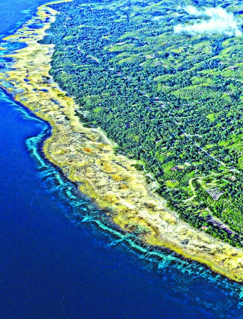
The 137.003 Â of coastal area along the shores of Loon and Maribojoc that “rose from the sea” and declared by the Department of Environment and Natural Resources (DENR) as a geological monument has been found “very unstable and is not suited as permanent habitation for now”.
Chief Geologist of the Mines and Geosciences Bureau (MGB) Liza Manzano told Governor Edgar Chatto and top officials of Loon and Maribojoc that “the area is very unstable. You cannot put up structures in that area”.
The MGB’s position was explained during a joint meeting yesterday afternoon at the Governor’s Mansion with Governor Edgar Chatto, officials of the municipalities of Loon and Maribojoc, the Sangguniang Panlalawigan represented by 1st District Board Member Abeleon Damalerio, Â DENR7 Regional Director Isabelo Montejo, MGB7 Regional Director Loreto Alburo and PENRO Nestor Canda.
Manzano who conducted a study of what is now known as an “uplifted reef flat” cautioned the Local Government officials that the 458 hectares of Loon and Maribojoc’s coastal zone “is still moving and is open to surges, tsunamis, liquefaction, ground subsidence and has sinkholes and cave systems”.
SAFETY FIRST
However, Manzano allayed fears of municipal officials that “a geological monument is not a hindrance to the livelihood of the people” citing the Chocolate Hills in the towns of Carmen, Sagbayan and Batuan as a beehive of economic activity under a declaration as a geological monument.
“As long as the development plans of the LGU’s does not put pressure on the uplifted reef then economic activities can be implemented”, according to Manzano.
She further clarified that the declaration by the DENR as recommended by the MGB was “to answer under what classification the uplifted area will fall” and foremost ” for the safety of the people living in the area”.
“The reason why we recommended for the area to be declared as protected was we were scared because people started building on the uplifted site reportedly 18 structures even as the area was still moving”, said Manzano.
Manzano also informed the body that a proposal submitted to the United Nations Development Programme (UNDP) to declare Bohol as a geo-park and the Loon-Maribojoc uplifted  reef flat as a geo site is now being considered.
ANTI LGU
The meeting was called by Chatto to thresh out misunderstandings and confusion among officials of both Loon and Maribojoc stemming from a controversial DENR Admistrative Order No.2015-08 signed by DENR Secretary Ramon Paje declaring 137.0031 hectares of the 458 hectares of the Loon – Maribojoc “uplifted coast” as a geological monument.
Loon Mayor Lloyd Peter Lopez, M.D. and Maribojoc Mayor Leoncio Evasco castigated DENR officials for issuing the order without prior consultation with the officials and residents of the affected areas.
Loon Vice Mayor Elvi Peter Relampagos branded the DENR order as “anti local government” for issuing a policy statement without taking into consideration the pulse of the people considering that the marching order of the national leadership is “kayo ang bosses ko” (You are my boss).
But MGB Regional Director Alburo assured the local officials present that “we are all for local autonomy and whether that perception might be true or not that depends on the circumstances leading to the issuance of the administrative order”.
“There was partial consultation”, this was the statement issued by the Department of Natural Resources (DENR) in response to allegations by  municipal officials of two Local Government Units (LGU’s) over non consultation prior to the issuance of an order declaring parts of their seashores as a geological monument.
Nestor Canda, Provincial Environment and Natural Resource Officer (PENRO) expressing surprise over the accusations hurled against the DENR told DYRD “Inyong Alagad” the existence of communications between the agency and the LGU’s concerning the possible issuance of an order is proof that there was “prior notice”.
DEFERMENT
During the meeting at the Governor’s Mansion, Lopez and Evasco together with their respective Sangguniang Bayan’s agreed to adopt a resolution urging the DENR to “withdraw the implementation of the order”.
Evasco was emphatic in moving for the halt in the implementation of the DENR order with Lopez seeing the need of an administrative order but one that will reflect the needs of the municipal stakeholders.
However the DENR speaking through Regional Director Montejo said that “there should be a scientific basis to repeal or defer the implementation of the order since
Lopez also suggested that both the municipal SB will meet again to hammer out their proposals for the amendment of the administrative order even as he maintained that the it’s implementation should be deferred and amendments be introduced.
Board Member Damalerio raised queries on the process leading to a Presidential Proclamation (PP) as geological monument, management and ownership of the geological monument and the status of the remaining 321 hectares of the 458 hectares uplifted area after the 137.003 has been declared as geological monument through a Presidential Proclamation.
Montejo explained that the remaining 321 hectares will be the subject of scientific studies that would determine the safety of the area as mentioned by Manzano since the declaration of the uplifted reef flat as alienable and disposable might jeopardize the lives of those would avail of the land classification.
Montejo further emphasized that all issues pertaining to the existence of the DENR order will be resolved within the ambit of scientific and socio demographic studies that will determine the safety of the area.
The administrative order, according to Montejo is the first step in the long process leading to a Presidential Proclamation and legislation with inputs from the forthcoming municipal dialogues included in the recommendations to the President.
In one fell swoop, the two municipalities lost jurisdiction over their seashores but has bonded more closely coordinating their environmental conservation and economic development efforts, potential benefits, developmental plans that are perceived to have been derailed by the issuance of the DENR Administive order.
Chatto, on his part has extended to the municipalities the influence of his office to broker a deal that would redound to the benefit of all the stakeholders of the Loon-Maribojoc uplifted reef flat now declared as a geological monument. (CMV)