The tropical depression with local name “Marce” may intensify into a storm next week, bringing cloudiness and rain mostly over Luzon and the Visayas.
Such intensification may occur between Sunday (Nov. 27) and Monday (Nov. 28) while ‘Marce’ is over West Philippine Sea, said weather forecaster Obet Badrina from State-run Philippine Atmospheric, Geophysical and Astronomical Services Administration (PAGASA).
“Cloudy skies with light to moderate rain and thunderstorms are possible in Luzon and the Visayas during the period,” he said.
Weather in Mindanao, on the other hand, will be clearing up towards being generally fair, he noted.
Badrina said even if “Marce” intensifies into a storm, there’s nil chance for this tropical cyclone to reach typhoon category.
“If ‘Marce’ becomes a storm, we expect it to weaken into a tropical depression between Monday and Tuesday (Nov. 29) after exiting the Philippine Area of Responsibility (PAR),” he said.
He based such forecast on expected intensification of the northeast monsoon or “amihan”.
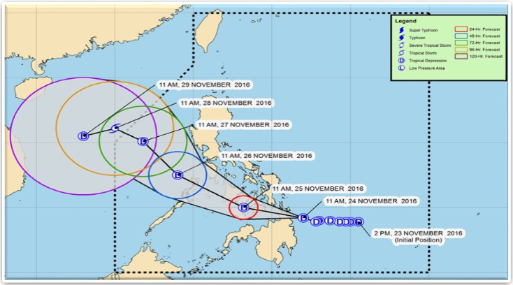
In its severe weather bulletin 8 released Thursday afternoon, PAGASA said “Marce” will likely move northwest at some 19 kph.
PAGASA forecasts “Marce” to be at some 540 km west of Iba, Zambales by Monday morning — already outside PAR.
“Marce” was 105 km north-northeast of Surigao del Sur province’s Hinatuan municipality as of 1 p.m. Thursday, PAGASA noted.
“Marce” packed maximum sustained winds of 45 kph near the center and gustiness of up to 55 kph.
“Estimated rainfall amount is from moderate to heavy within the tropical depression’s 300-km diameter,” noted PAGASA.
Government raised tropical cyclone warning signal 1 over Luzon’s Romblon and Cuyo Island; the Visayas’ Biliran, Southern part of Samar, Southern part of eastern Samar, Leyte, Southern Leyte, Bohol, Cebu including Bantayan and Camotes Islands, Siquijor, Negros Oriental, Negros Occidental, Iloilo, Capiz, Aklan, Antique andGuimaras, as well as Mindanao’s Surigao del Norte including Siargao Island, Surigao del Sur, Dinagat Islands, Agusan del Norte, Agusan del Sur, Misamis Oriental and Camiguin.
“Residents of areas under signal 1 and the rest of Eastern Visayas are advised to be alert against possible flashfloods and landslides,” PAGASA said further.
According to the weather bureau, “Marce” slightly accelerated while moving towards Surigao del Norte.
PAGASA forecast “Marce” to landfall there around Thursday afternoon or evening. (PNA)