Typhoon Ursula on Tuesday afternoon made landfall over Salcedo, eastern Samar bringing violent winds near the storm’s center and placing the entire province of Bohol under Tropical Cyclone Warning Signal (TCWS) No. 1 for the first time since the weather disturbance entered the Philippine Area of Responsibility.
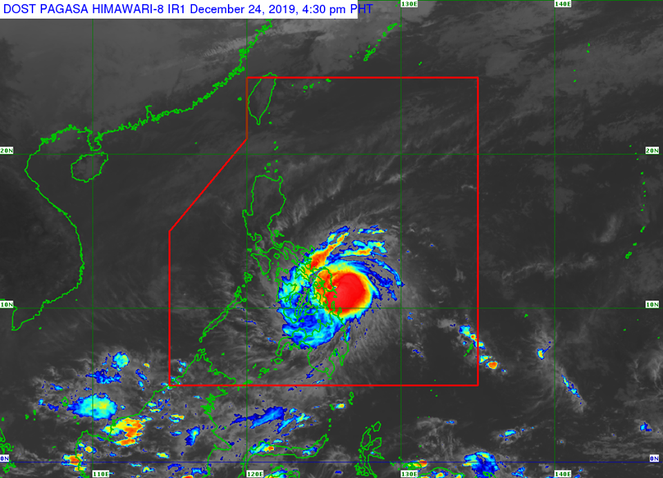
PAGASA in its 5 p.m. bulletin said that the eye of the typhoon was located, based on all available data, at 20 kilometers northeast of Guiuan, Eastern Samar as of 4:45 p.m.
It was packing maximum sustained winds of up to 120 kph near the center and gustiness of up to 150 kph as it headed west at 25 kph.
PAGASA only earlier hoisted TCWS over the northeastern segment of Bohol since Monday but more localities in the region were placed under a storm signal as the cyclone intensified and moved westward on Tuesday afternoon.
“Moderate to strong winds to begin affecting Bicol Region and portions of Central Visayas tonight,” said PAGASA.
According to the Visayas PAGASA Regional Services Division, stormy weather with moderate to heavy occasional rains or thunderstorms may be experienced in Tagbilaran City and the rest of Bohol on Tuesday and Wednesday, Christmas Day.
Visayas PAGASA said that winds with speed of 60 kph to 80 kph may be experienced in the province while seas around the province are expected to be “very rough.”
THE FOLLOWING AREAS HAVE BEEN PLACED UNDER STORM SIGNALS:
TCWS #3(121-170 km/h winds prevailing or expected in 18 hours)
Masbate including Ticao Island
Northern Samar, Samar, Eastern Samar, Biliran, Leyte, and extreme Northern Cebu including Camotes Island (Daaanbantayan, Medellin, Bantayan, Sta. Fe, Madridejos, San Francisco, Poro, Tudela, Pilar)
TCWS #2(61-120 km/h winds prevailing or expected in 24 hours)
Southern portion of Quezon (Mulanay, San Narciso, San Andres, San Francisco), Marinduque, Oriental Mindoro, Occidental Mindoro including Lubang Island, Romblon, Albay, Sorsogon, Burias Island, Calamian and Cuyo Islands
Central portion of northern Cebu (Bogo City, Tabogon, Tabuelan, Borbon), northeastern Iloilo (Carles, Balasan, Estancia, Batad, San Dionisio, Sara, Concepcion, Lemery, Ajuy), northern Antique (Libertad, Pandan, Sebaste, Culasi, Tibiao), Capiz, Aklan, Southern Leyte and northern Negros Occidental (Enrique B. Magalona, Victorias, Manapla, Cadiz, Sagay, Escalante, Toboso)
Dinagat Islands
TCWS #1(30-60 km/h winds prevailing or expected in 36 hours)
Bulacan, Bataan, Metro Manila, Rizal, Cavite, rest of Quezon, Laguna, Batangas, Camarines Sur, Camarines Norte, Catanduanes, northern Palawan (Linapacan, El Nido, Taytay, Araceli, Dumaran, San Vicente, Roxas)
Rest of Cebu, Bohol, Siquijor, the rest of Antique, the rest of Iloilo, Guimaras, Negros Oriental, and the rest of Negros Occidental
Surigao del Norte including Siargao and Bucas Grande Islands